Chulu Far East (6059m) peak climbing

Trip Facts
  • Duration 19 Days
  • Destination Nepal
  • Difficulty Level Strenuous +
  • Max Altitude 6059m
  • Trip Start and End Kathmandu-Kathmandu
  • Best Season Oct-Nov, Apr-Mai

Annapurna circuit with Chulu Far East (6 059m.) peak climbing

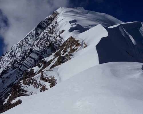
The Chulu Far East (6059m) peak climbing is considered one of the most accessible and straightforward among the three peaks, and it requires relatively little previous technical climbing experience, though it is by no means easy. Climbers should have the general knowledge to walk with crampons and an ice axe along the fixed ropes on the mountain. The steep terrain and screed slopes near the summit make it a bit challenging.

Chulu Far summit photo
The peak is often combined with the classic Annapurna Circuit Trek and Nar Phu Valley Trek. The approach to the base camp is from the village of Ngawal village. The common route to the summit is via the North-East Ridge, which was first climbed in 1955 by a German expedition.

I had a great experience having my first mountaineering training on the Chulu Far East peak in 1992 AD. Therefore, this mountain can be suitable for enthusiasts of all levels.

Chulu Far East is situated high above the Manang Valley, rising parallel to the Chulu East range, offering breathtaking views across to Annapurnas II, III, and IV, Gangapurna, Glacier Dome, Dhaulagiri, Tilicho Peak, and Manaslu.


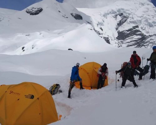
Approach: The route takes us through the Annapurna classic circuit trail, up to Ngawal village or Hungde airstrip. From here we follow the Julu Khola, which takes us to the north flank of the Chulu East, & the Far East with steep climbing with a view of a waterfall whose source is the Chulu East glacier. From the base camp, we start to attempt the summit, at the beginning, we walk on the rocky and steep icy way, the best method is to fix the Rope and then reach southwest. And right ridge goes to the Chulu Far East summit, and the East summit continues down to deep snow crevasses, which is technically very difficult among trekking peaks in Nepal. So we need at least 4 to 6 days of climbing period from the base camp, the camp will be at 5500m and the camp should be at least below the ridge. The next day early in the morning follow the north ridge to the Summit


Itinerary

ExpandCollapse
  • Accommodation Hotel
  • MealsFree
  • Max Altitude1340m
  • Accommodation Hotel
  • MealsB
  • Max Altitude1340m

The Kathmandu Besishahar is 185km. long road, It begins with the Prithivi Highway, leading up to Dumre, and then connects to Besishar via the Bhanubhakta Highway. Following the Trishuli River until Mugling, we then traverse the Marshyangdi River, offering breathtaking views of the Annapurna massif, Ganesh Himal, and Manaslu. Along the way, there's an opportunity to experience the adventure of rafting on the Trishuli River. Upon reaching Besishahar, if traveling by bus, we switch to a local jeep for the remaining 50 km journey to Dharapani.

The recently constructed road condition between Besishahar and Manang is quite narrow, bumpy, and dusty graveled. You may need to change your vehicles sometimes due to natural and unforeseen events, such as landslides and other circumstances. Additionally, the bumpy road may make your trip slightly tedious.


  • Accommodation Lodge
  • MealsBLD
  • Max Altitude1900m.

From Dharapani climb gradually up to Bagarchap, which is another Tibetan village from here we start to see impressive view of high summits: Manaslu, Ngadichuli, Lamjung, Annapurna 2.
We continue to climb up by the serpent path in the conifers forest (Pines of Himalayas). It is a pleasant journey in the conifers forest (Pines, firs, cedar.) with seizing the massive Manaslu and Lamjumg Himal. We find the first Rhododendrons (flourish in March/ April). Every entrance of the village consists of prayer wheels and flags, the smell of burnt juniper incense as offerings, which welcome us. The glaciers are more and more close and the temperature rapidly falls in the night.

  • Accommodation Lodge
  • MealsBLD
  • Max Altitude2700m.

We continue towards Brathang, it is the last village before we arrive in the Manang Valley. After walking one and half hour from Brathang in the Pine forest and after crossing the suspension bridge, we are above 3000m, we entered the Manang valley bordered by the Annapurna 2,3 and 4, Gangapurna and the Tilicho Peak, and the Chulu East, West and Fareast, as well as by the Pisang Peak.

  • Accommodation Lodge
  • MealsBLD
  • Max Altitude3300m

We begin our walk slowly to adapt the altitude. Our initial climb takes us to Higher Pisang, where we visit the Buddhist monastery. We traverse through the open pine forest, past minerals, and juniper bushes for the final time. After an hour of strenuous climbing, we reach Gyaru, where we have our lunch. It is another village where the wind disturbs the calm atmosphere. We enjoy an impressive view of the Annapurnas. After two hours of walking along the mountain flank, we arrive at Ngawal, which is also a sizable village at a high altitude.

  • Accommodation Lodge
  • MealsBLD
  • Max Altitude3600m.

The trail crosses the Julu Khola before gradually ascending to a serene apple field, recognized for its stone huts and picturesque vantage points. Proceeding beyond, we pass by a formidable waterfall, sourced from a lofty cliff in the distance, before reaching a small meadow utilized to feed local goats and yaks. Eventually, we reach Yak Kharka, where we will set up camp near a breathtaking ridge that provides views of the formidable mountains towering over the valley.


  • Accommodation Tent
  • MealsBLD
  • Max Altitude3750m.

In the midst of these untamed and tranquil surroundings, we continue to hike up after breakfast, navigating the winding trail through unreserved pasturelands until we reach a meadow with a prominent rock formation. Our campsite will be set up near a breathtaking viewpoint, providing panoramic views of the majestic Annapurna giants, which stand tall above the clouds.


  • Accommodation Tent
  • MealsBLD
  • Max Altitude4600m

We continue ascent towards Camp I. The route is not that technical. But it would be better to remember that we are climbing on high altitudes. We have magnificent views of Annapurna range and including Gangapurna and Lamjung Himal


  • Accommodation Tent
  • MealsBLD
  • Max Altitude5200m.

Going to be long day today of the trip.  Therefore, we would wake up much earlier today. Each moment we have to work hard through the icy high-altitude with crampons and rope but the outstanding high Himalayan scenes are such tempting that our eyes love to watch more over the horizon than on our trail. After summiting, we return back to base Camp


  • Accommodation Tent
  • MealsBLD
  • Max Altitude6059m

Security day or second attempt atop in case of bad weather / not enough acclimatization) If the first attempt is successful then you can use this day to rest somewhere at appropriate place or have a strolling time in Kathmandu

  • Accommodation Tent
  • MealsBLD
  • Max Altitude4600m.

Today we return back to the Manang via Chulu base camp. The path is descent so we walk as fast as possible to reach Manang.


  • Accommodation Lodge
  • MealsBLD
  • Max Altitude3540m.

Today also we need to walk the entire day along the ascent path till we reach our destination at Phedi.  On the way we see yaks grazing around the fields.

  • Accommodation Lodge
  • MealsBLD
  • Max Altitude4400m.

We leave early in the morning around 3 am to the direction of Thorang La Pass (5416m). The climbing is slowly and progressive because we pass the bar of 5000m, the day rise and the surroundings view of the massif Annapurna are unforgettable. After walking entire morning on the easy path we reach the Pass. We descend to the direction of Muktinath with the magnificent view of the Nilgiris and the massif  of Dhaulairi (8167m). Arrive to Muktinath. Muktinath is a famous temple of Hindus in the early 19th century the Hindus consecrated a Vishnu temple and   named it Muktinath- Lord of liberation.  We find Buddhists monasteries also. The natural burning flame inside the Gompa and we can hear sound of water under ground as well. We could see the pilgrims purifying themselves in the108 sacred water fountains.


  • Accommodation Lodge
  • MealsBLD
  • Max Altitude5416m./3800m.

Descend to Kali Gandaki around 10 a.m. in the morning the wind blows strongly and it is very difficult to go ahead. We should have a pair of glasses to protect the eyes. On the way visit the monastery of Zharkot.

  • Accommodation Lodge
  • MealsBLD
  • Max Altitude2700m.

We take an early morning the spectacular flight down to Pokhara through the huge mountains of the Annapurna and Dhaulagiri ranges tower above us as

(If the weather of Jomsom airport is uncertain the flight either Jomsom  to Pokhara or Pokhara to Jomsom can be cancelled. In that case you may have travelled by road. The recent under construction road condition is quite narrow & gravelled between Jomsom and Beni.. Some times you may need to change your vehicles several times causes landslides and other circumstances. (as well as the bumpy road may make your trip slightly bore.)

  • Accommodation Hotel
  • MealsBLD
  • Max Altitude900m
  • Accommodation Hotel
  • MealsBL
  • Max Altitude1340m.
  • Accommodation Hotel
  • MealsB
  • Max Altitude1340m.

(Departure time from hotel will be fixed as per your flight schedules for the return)


  • MealsB

Not satisfied with this regular itinerary?

Are you thinking to plan your custom trip now.

Included
  • Transfer:  Airport / Hotel pick up & drop by private car/van as per group size.
  • Transportation:  Kathmandu/Beshishahar/Dharapani by bus/jeep, Pokhara/Kathmandu traveling by tourist bus
  • Flight Jomsom/Pokhara.
  • Full board meals during the trekking, accommodation in twin sharing Lodges.  (Meals can be choose from Menu) (Breakfast, Lunch, Dinner, Tea and coffee.) (Except beverage.). while mountaineering tent will be used at base camp
  • Altitude tent (each tent for 2 persons)
  • An Experienced & Professional well-trained mountaineering  English speaking guide
  • Entry permit for Annapurna Conservation Area Project (ACAP)
  • Royalty of Chulu East peak for Nepal Mountaineering Association (NMA)
  • 4 nights in hotel International Guest House at Katmandu or Similar category on a twin sharing bed and BB basis.
  •  First aid kit will be available during the trek.
  • All personal gears and group equipments will be carried by porter i.e. (1 porter per client, one porter carry max 20-25 kg).
  • Nepalese crews  Insurance.
  • Domestic airport taxes.
Excluded
  • Meals in Katmandu except breakfast (Near about $US 10 – 15 per day/person)
  • Nepal entry Visa Fee (You can obtain a visa easily upon your arrival at Nepal ’s Airport in Katmandu).
  • International Airfare and Airport Taxes.
  • Any kind of Alcoholic, hot and cold drinks or bar menu.
  • Personal trekking and Mountaineering equipment such as (crampons, Ice axe, ropes & sleeping bags... etc), travel and medical insurance & helicopter in case for emergency Rescue evacuation, personal expenses,
  • Any expenses caused by reason beyond our control such as roadblock due to natural climates and accidents and unforeseen events etc…
  • Tips and Gratitude.