Manaslu circuit through ancestral Gurung village of Laprak

Trip Facts
  • Duration 19 Days
  • Difficulty Level Strenuous
  • Max Altitude 5200m.
  • Trip Start and End Kathamdnu - Kathmandu
  • Best Season oct-Nov, Apr-Mai
Highlights

The itinerary follows Daraondi Valley for the first week of the trek via Barpak and Laprak ancestral Gurung village then follows  Budhi Gandaki Valley, the trail continues northward passing through many villages of Tibetan origin. These villages offer an opportunity to explore their customs and cultures, monasteries, prayer flags, prayer wheels, and prayer walls.

Manaslu circuit through the upper route that leads through ancestral Gurung village of Laprak

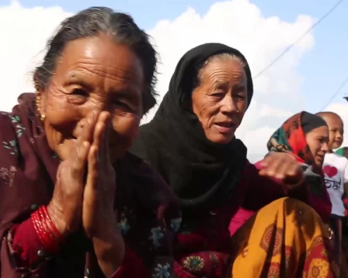
The Manaslu Circuit, also known as the round Manaslu trek itinerary, takes you through the upper ancestral Gurung villages of Barpak and Laprak. These villages are also known for being the epicenter of the massive earthquake of 2015. Other Gurung villages along the route include Singla and Khorla, where you can immerse yourself in the local culture and interact with the friendly villagers with warm hospitality experiences. The trek begins at Barpak and you will join the classic Manaslu circuit route, at Khorla besi thereafter following the Budigandaki valley up to its source at Larkey La pass.
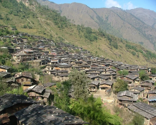
The ancestral Gurung village Laprak

Trekking in the Manaslu region offers a unique adventure in Nepal, showcasing the spectacular beauty of the Himalayas along the border of Nepal and Tibet. This area is renowned as one of the finest tourist destinations in Nepal, offering panoramic views of the majestic Himalayan range. The valley serves as a sanctuary for highly endangered animals such as Snow Leopards and Pandas, as well as various species of birds, and mammals like grey wolves, musk deer, blue sheep, and the Himalayan Thar, along with butterflies and reptiles. The region is also rich in medicinal herbs and aromatic plants. Mt. Manaslu (8163m) stands above the Samagon, having it the eighth-highest peak in the world. The region was opened for foreign tourists for trekking purposes only in 1992, and special permits are mandatory for all foreigners to enter this mythical universe rooted in the living Tibetan tradition.

During the trek, you will have the opportunity to admire the breathtaking mountain ranges of Ganesh Himal and Sringi Himal, as well as Mt. Manaslu itself. The challenging terrain and the mix of Gurung and Tibetan villages add to the charm of the trek. The upper section of the Manaslu region is known for its rich biodiversity. The ethnically Tibetan inhabitants speak their dialect, while the Gurung people have their language and lifestyle.

Itinerary

ExpandCollapse
  • Accommodation hotel
  • MealsFree
  • Max Altitude1340m
  • Accommodation hotel
  • MealsB
  • Max Altitude1340m.

Depart early in the morning to destination of Gorkha - Barpak about 133km in tarmac road and about 50km is gravel and quite narrow road, your lunch at a local restaurant on the way to Barpak Night in a tea house


  • Accommodation Lodge
  • MealsBLD
  • Max Altitude1900m

The first day of our trek starts with a picturesque climb along with a spectacular view of Bauddha Himal at the backdrop and the scenic Barpak village looking back down. At the end of the climb, the path goes through an open forest of rhododendrons. The rhododendrons blooming brilliantly in March/April make them more enthusiastic. Once we arrive at the top, we can experience an extraordinary view of Bauddha Himal, Shringi Himal, and Ganesh Himal if the weather is clear, and then later descend towards the village of GURUNG, Laprak, by walking through the stone staircase in the flank of the mountain.  

If time permits us, we visit the honeycomb Gurung village and explore the lifestyle, tradition, and culture of this region. The village consists of more than 500 houses and the number of inhabitants is nearly 3000.


  • Accommodation Lodge
  • MealsBLD
  • Max Altitude2200m

Today is quite long day, walking through the beaten track up and down hill trail. In the morning our trek starts trough terrace fields and stone staircase up to Jyarbu khola and cross the suspension bridge over it and gentle climb up equally we have descend from Laprak through the mountain trail. We move towards the others Gurung villages "Singla, and Khorla gaon.  The trail goes steep down from Singla to Khorlabensi. We will have spectacular view towards Ganesh Himal range but a bit hard on the knees due to rocky trail.

  • Accommodation Lodge
  • MealsBLD
  • Max Altitude900m

After break fast we start our trek through rocky trail along Budigandaki gorges. After few hours of walk we at Tatopani (hotsprings) where the porters will no doubt take the opportunity to have a quick wash. After Tatopani the trail crosses to the left bank of the Buri Gandaki over a suspension bridge. After a section through forest we reach the village of Doban. At this point the Buri Gandaki descends an impressive series of rapids and further up the valley the river opens up and meanders across a broad graveled bed. The camp for tonight is in the village of Jagat which is gate way of Manaslu region.

  • Accommodation Lodge
  • MealsBLD
  • Max Altitude1300m

We continue to trek through the right bank of Budigandaki, after village of Sirdibas we cross the Buri Gandaki on a large suspension bridge and climb steeply to Philim. The trail traverses the hillside and passes Ekle Bhatti before crossing back over the river below the confluence of Buri Gandaki and Siyar Khola. From here we enter a dramatic section of the gorge high above the river. Look out for orchids on the walls of the gorge above the trail. The trail makes its way up the west side of the valley and offers a pleasant walk through bamboo forests to the village of Deng.


  • Accommodation Lodge
  • MealsBLD
  • Max Altitude1900m

We are entering in the area influenced by Buddhism. After a few more ups and downs through forests, the trail turns a corner and arrives at Ghap through an intricate Mani stones (prayers wall) well preserved paintings and elegant mani wall. Look out across the river for views of the village of Prok perched on the plateau over the river. The valley becomes steeper and there is a long climb through dense bamboo and rhododendrons to the village of Namrung at 2630m. The trail now enters the Nupri region. The people here are descendants of Tibetan migrants who arrived over 500 years ago.


  • Accommodation Lodge
  • MealsBLD
  • Max Altitude2630m

As we arrive in the higher altitude, it is logical that to be walking slow and short distance of stopping place. Above 3000m the concentration of oxygen in the air you breathe starts to drop off markedly, reducing the amount of oxygen and decreasing air pressure at altitude. So it is recommended to walk
at the rhythm. We feel more typical Tibetan features include the entrance gates to the villages, mani walls and
Buddhist gompas. Beyond here the valley opens out and soon passes through the Tibetan village of Sho. Above this village we get views of Manaslu and Naike Peak and from the next village of Lho we see Ganesh I down the valley.


  • Accommodation Lodge
  • MealsBLD
  • Max Altitude2800m

An easy trek today, gentle climb with few meters of descends following the right bank of the river with views of Peak 29 ahead. A couple of hours climbing through the forest brings us to the village of Shyala, offering superb views of Phungi, Manaslu and Himal Chuli. Crossing a wide pasture with many marmots we enter the village of Samagaon. Our camp is at the top end of the village below the impressive Sama Gompa with impressive views of Manaslu.

  • Accommodation Lodge
  • MealsBLD
  • Max Altitude3400m

Follow the Buri Gandaki northwards to a bridge over a side stream where the trail forks: the left leading towards the Manaslu Base Camp, the other passing several mani walls heads for the Larkya La. The valley widens along an easy trail past juniper and birch forest to the stone huts at Kermo Kharka, then drops off a shelf to cross a wooden bridge and climbing between a fork in the river to a promontory. From this vantage point, one can see the white stone kani marking the entrance to Samdo.

  • Accommodation Lodge
  • MealsBLD
  • Max Altitude3800m

We spend two nights at Samdo to help acclimatization. There is a good day walk towards  Gya La which is the trading pass with Tibet.


  • Accommodation Lodge
  • MealsBLD
  • Max Altitude3800m

Today we start the ascent to the pass by descending through fields to an old mani wall and stone arch before dropping to the river and crossing on a wooden bridge.
This place shows up on maps as the mythical Larka Bazaar, which used to be a flourishing market, but there is nothing remaining there now from here the trail starts climbing through tundra and juniper; the huge Larkya Glacier coming from Manaslu can be seen from here. We reach Larkya Phedi ( Dharamsaala), where there is a small lodge, built to serve travellers crossing the Larkya La which lies now just ahead.

  • Accommodation Lodge
  • MealsBLD
  • Max Altitude4400m.

After an early start, we soon reach the ablation valley on the left side of the Larkya Glacier with impressive views of Cho Danda and Larkya Peak. We continue walking along glacial moraine and start making the gradual ascent to the Larkey pass. From the top, there is a panorama view of Himlung Himal, Cheo Himal, Kang Guru and Annapurna 2.
On the descent the trail follows the top of the moraine to the west and makes a set of steep, rough witchbacks as it crosses the moraine then descends more gently The trail now becomes easier to follow and reaches a small meadow and spring at 3800m. The valley becomes wider as the trails heads down to a large meadow to our camp site

  • Accommodation lodge
  • MealsBLD
  • Max Altitude5200m/3800m

This morning the trail drops to a glacial stream at the headwaters of the Dudh Khola, crosses a wooden bridge and descends into pine and rhododendron forest. The trail continues through fields and intermittent stands of rhododendron and oak to arrive at Tilje, a large Gurung village.

  • Accommodation Lodge
  • MealsBLD
  • Max Altitude2300m

Exit the village through a stone arch, cross the Dudh Khola and follow along its embankment descending through scrub forest. The walls of the Marsyangdi Valley loom larger and finally the houses of Dharapani appear in the distance. Pass through Thonje via a suspension bridge over Marsyangdi and through a chorten-shaped arch. You will here local jeep for Besishahar which follows the Annapurna circuit route in reverse as you pass through the steepest part of the Marsyangdi gorge. Late afternoon arriving at Besishahar

  • Accommodation Lodge
  • MealsBLD
  • Max Altitude850m.

Today travelling by private vehicle or local bus Kathmandu high way (180km)


  • Accommodation Hotel
  • MealsBL
  • Accommodation Hotel
  • MealsB
  • Max Altitude1340m

(Departure time from hotel will be fixed as per your flight schedules for the return)


  • MealsB
  • Max Altitude1340m

Not satisfied with this regular itinerary?

Are you thinking to plan your custom trip now.

Included
  • Transfer:  Airport / Hotel pick up & drop by private car/van as per group size.
  • Transportation: Kathmandu/Barpak traveling by reserved jeep Gorkha, Bhulbhule/Kathmandu traveling by collective bus
  • Full board meals during the trekking, accommodation in twin sharing Lodges/tea house.  (Meals can be choose from lodge Menu) (Breakfast + tea/coffee, Lunch+tea/coffee, Dinner+tea/coffee.) (Cold drinks are not included nor hot drinks between three major meals)
  • An Experienced & Professional Government license holder English speaking trained Trekking guide.
  • Entry permit for Annapurna Conservation Area Project (ACAP), Entry permit for Manaslu Conservation Area Project (MCAP), You are required 2 passport size photos.
  • Special trekking permit for Manaslu
  • 4 nights in hotel International Guest House or Similar category on a twin sharing bed and
  • First aid kit will be available during the trek.
  • All personal gears and group equipments will be carried by porter i.e. (1 porter for 2 clients, one porter carry max 20-25kg).
  • Staffs Insurance.
Excluded
  • Meals in Katmandu except breakfast (Near about US $ 15 – 20 per day/person)
  • Nepal entry Visa Fee (You can obtain a visa easily upon your arrival at Nepal ’s Airport in Katmandu). You are required 2 passport size photos.
  • International Airfare and Airport Taxes.
  • Entrance fees in the Historical site /Monument at Kathmandu
  • Any kind of Alcoholic, hot and cold drinks or bar menu.
  • Personal trekking Equipment, travel and medical insurance & helicopter in case for emergency Rescue evacuation, personal expenses,
  • Any expenses caused by reason beyond our control such as roadblock due to natural climates and accidents and unforeseen events etc…
  • Tips and Gratitude.


Additional Information

Side Trip to SerangGomba

Unlike Bihi Phedi, which must remain an enigma rather than an entity, Bihi (2130m) is a proper settlement with many small Gombas, situated on the hillside. Gyahu is another village further up. The most famous side trip from here is to visit SerangGomba, one of the largest Gombas in the Kutang valley, situated below ShringiHimal.
The trail to Serang Gomba follows the eastern bank of the SerangKhola for about 3 hours before crossing to the west bank. A tough 500m climb ensues, leading to a small village known as Syarang (about 3 hours from the riverbed). This section of the trail is rocky and characterized by many mani walls. This is because the famous Tibetan Sage, Guru Rimpoche, is believed to have established this trail. Syarang village and the Kutang region are renowned for the skills of the local stone carvers and sculptors. En route, you'll find Golpon Gomba located on a small hillock with beautiful views. The trail from Syarang passes through a kani and then enters some forest as it climbs to over 2000m. SerangGomba is situated just after a deep gorge, nestled in the valley between two glaciers descending from Shringi Himal. Along the way, you'll encounter several interesting kanis, chortens, finely carved mani walls, and a cave monastery. Two watermills owned by SerangGomba are located another 3 hours' walk away.
Serang monastery is the most important and the largest gomba in Kutang. It is also known as “Beyul Kyimulung,” the Hidden Lands of Happiness, established by Guru Rimpoche (Padma Smbhava). The cult of the "hidden valley" is found here, where the faithful take refuge during times of strife and to ward off the enemies of the Dharma. Here, they hope to find a land of peace and plenty, places that are usually located in isolated and inaccessible areas throughout the Himalayas. Both SerangGomba and the Kyimulung area have so far escaped the notice of the outside world.
The way back to main trail is the same trail until 30mins before Syarang, then its leads to a mules trail. This train proceeds through oak forest to over 3000m. from where you can see Manaslu to the west. There is also scenic view of the Prok and the Budi Gandaki valley along your trail you might encounter Himalaya Tahr and certainly many different birds-Himalayan Griffons and Lammergeyers, with luck.

Day Trip to Kal Tal

The day trip to Kal Tal (Chhuman Lake) begins from Prok Village, a large settlement in the area. Prok Village is distinguished by its flat and gently sloping meadows, along with a dense, minimally disturbed forest below the Rani (Lidanai) Ridge. On the horizon, you can see the towering LapechunHimal Ridge, offering panoramic views across the Budi Gandaki River.
We should commence our journey early in the morning to reach KalChho Lake, which is probably the largest lake in the eastern Manaslu region. This stunning lake is situated at an altitude of 3,574 meters to the east of Bautha and Himalchuli and is surrounded by a birch forest. At the western end of the lake, you'll find the KalChokang Monastery (Gomba). A trail encircling the lake provides magnificent views of the mountains and showcases the rich diversity of flora and fauna in the area. As the elevation gain from Prok on this hike exceeds 1,000 meters, it will take a full day to reach Kal Tal. In the late afternoon, we will descend back to Prok.

Hinang Gomba:

Today we have an optional side trip to HinangGomba at 3,120 meters. Once you reach Lihi (2,900 meters), if anyone is interested in visiting HinangGomba, it is recommended, if anyone is interested to visit the HinangGomba and it is recommended for those who have spare time and wish to explore beyond Lihi village. It takes approximately 1 hour to walk from Lihi village, ascending towards HinangKhola, where you'll discover the HinangGompa. Upon arrival, you will receive a warm welcome from the monks, who will introduce you to their culture. Standard accommodation and basic food options are available if you choose to spend the night there.
 
If you decide to continue ascending the Himalchuli range, you'll be rewarded with spectacular mountain views and have the opportunity to visit the Hinang Glacier. It is highly advisable to hire a local guide from the village who is familiar with the area and the glacier to ensure a safe and informative experience. After exploring the area for a few hour and returned to HinangGomba and then descended towards Lo village to spend the night.