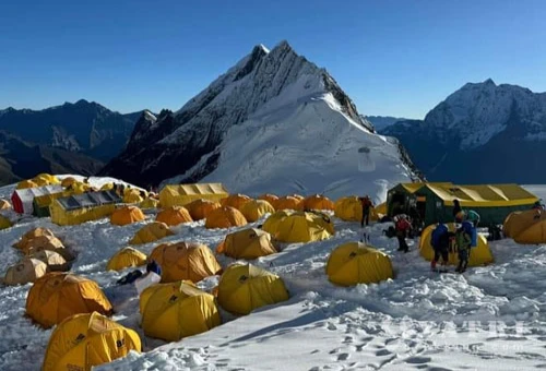
The mythical universe of Manaslu trek

Trip Facts
  • Duration 16 Days
  • Destination Nepal
  • Difficulty Level Strenuous
  • Max Altitude 5200m
  • Trip Start and End Soti - Besishahar
  • Best Season Oct- Nov, mar - Mai
Highlights
  • This is a geographically spectacular and culturally rich trek passing from the lower gorge to the Tibetan village of Samdo, Sama gaon of the upper Buri Gandaki.
  • The mountain views are sensational including Himalchuli (7,893m), Shringi Himal (7,187m), Ngadichuli (7,871m) ,and of course Manaslu (8,163m)
  • Larkya La at 5,200m is an impressive Himalayan pass to cross, it is a long day however would be a good objective for most hill walkers.
  • Manaslu Circuit would appeal to anyone looking for a challenging trek in a remote region of Nepal visited by relatively few other trekkers.


The mythical universe of Manaslu trek 16 days in Nepal

The Manaslu trekking trail provides magnificent views of mountains, a combination of rich cultural heritage, and biological diversity. The Manaslu region is one of the most delightful adventures in Nepal, as it provides spectacular beauty along the border of Nepal and Tibet. The trekking to Manaslu area has been considered one of the finest tourist destinations in Nepal, as one can enjoy the panoramic views of the majestic Himalayas like Manaslu, and Ngadi Chuli stretched across the area. Manaslu Valley is a sanctuary to many highly endangered animals, including Snow Leopards and Pandas, different species of birds, mammals, grey wolf, musk deer, blue sheep, and the Himalayan Thar, butterflies, and reptiles. Medicinal herbs and aromatic plants have also been recorded in the Manaslu region.

For Manaslu trekking, we follow Budhi Gandaki valley. The trail continues northward, passing through many villages of Tibetan origin. These villages offer an opportunity to explore their customs and cultures, monasteries, prayer flags, prayer wheels, and prayer walls.


Itinerary

ExpandCollapse
  • Accommodation Hotel
  • MealsFree
  • Max Altitude1340m

Departure to destination of Arughat for the first section of the road which is about 100km, lead through blacktop road and the rest of the road is about 55km which is graveled road, lunch will be done at a local restaurant on the way to Arughat, there could be change in our vehicle at Arughat, some time the local syndicators doesn't allow to go direct our vehicle to Soti (Arughat – Soti is about 12km graveled road)


  • Accommodation Lodge
  • MealsBLD
  • Max Altitude560m

Our route heads northwards following the Buri Gandaki river passing through terraced fields and scattered farmhouses. After while the valley narrows and in trek through the huge rock cliff but the road is enough wide and easy flat towards Lapu besi. We pass a number of small villages, tea houses until Machhekola


  • Accommodation Lodge
  • MealsBLD
  • Max Altitude900m.

After break fast we start our trek through rocky trail along Budigandaki gorges. After few hours of walk we at Tatopani (hotsprings) where the porters will no doubt take the opportunity to have a quick wash. After Tatopani the trail crosses to the left bank of the Buri Gandaki over a suspension bridge. After a section through forest we reach the village of Doban. At this point the Buri Gandaki descends an impressive series of rapids and further up the valley the river opens up and meanders across a broad graveled bed. The stop place for tonight is in the village of Jagat which is gate way of Manaslu region.


  • Accommodation Lodge
  • MealsBLD
  • Max Altitude1300m

We continue to trek through the right bank of Budigandaki, after village of Sirdibas we cross the Buri Gandaki on a large suspension bridge and climb steeply to Philim. The trail traverses the hillside and passes Ekle Bhatti before crossing back over the river below the confluence of Buri Gandaki and Siyar Khola. From here we enter a dramatic section of the gorge high above the river. Look out for orchids on the walls of the gorge above the trail. The trail makes its way up the west side of the valley and offers a pleasant walk through bamboo forests to the village of Deng.


  • Accommodation Lodge
  • MealsBLD
  • Max Altitude1900m

Today, we enter the area influenced by Buddhism. After a few more ups and downs through forests, the trail turns a corner and arrives at Ghap through an intricate Mani stones (prayers wall) well preserved paintings and elegant mani wall. Look out across the river for views of the village of Prok perched on the plateau over the river. We continue our treks, further while the trail becomes steeper and there is a long climb through dense bamboo and rhododendrons to the village of Namrung

  • Accommodation Lodge
  • MealsBLD
  • Max Altitude2630m

The trail now enters the Nupri region. The people here are descendants of Tibetan migrants who arrived over 500 years ago.Typical Tibetan features include the entrance gates to the villages, mani walls and
Buddhist gompas. Beyond here the valley opens out and soon passes through the Tibetan village of Sho. Above this village we get views of Manaslu and Naike Peak and from the next village of Lho we see Ganesh I down the valley.

  • Accommodation Lodge
  • MealsBLD
  • Max Altitude3180m

An easy trek today, gentle climb with few meters of descends following the right bank of the river with views of Peak 29 ahead. A couple of hours climbing through the forest brings us to the village of Shyala, offering superb views of Phungi, Manaslu and Himal Chuli. Crossing a wide pasture with many marmots we enter the village of Samagaon. After settle at lodge we will visit the impressive Sama Gompa with inspiring views of Manaslu.


  • Accommodation Lodge
  • MealsBLD
  • Max Altitude3400m

Follow the Buri Gandaki northwards to a bridge over a side stream where the trail forks: the left leading towards the Manaslu Base Camp, the other passing several mani walls heads for the Larkya La.
The valley widens along an easy trail past juniper and birch forest to the stone huts at Kermo Kharka, then drops off a shelf to cross a wooden bridge and climbing between a fork in the river to a promontory. From this vantage point, one can see the white stone kani marking the entrance to Samdo.

  • Accommodation Lodge
  • MealsBLD
  • Max Altitude3800m

We spend two nights at Samdo to help acclimatization. There is a good day walk towards  Gya La which is the trading pass with Tibet.


  • Accommodation Lodge
  • MealsBLD
  • Max Altitude3800m

Today we start the ascent to the pass by descending through fields to an old mani wall and stone arch before dropping to the river and crossing on a wooden bridge. This place shows up on maps as the mythical Larka Bazaar, which used to be a flourishing market, but there is nothing remaining there now from here the trail starts climbing through tundra and juniper; the huge Larkya Glacier coming from Manaslu can be seen from here. We reach Larkya Phedi ( Dharamsaala), where there is a small lodge, built to serve travellers crossing the Larkya La which lies now just ahead.

  • Accommodation Lodge
  • MealsBLD
  • Max Altitude4400m.

After an early start, we soon reach the ablation valley on the left side of the Larkya Glacier with impressive views of Cho Danda and Larkya Peak. We continue walking along glacial moraine and start making the gradual ascent to the Larkey pass. From the top, there is a panorama view of Himlung Himal, Cheo Himal, Kang Guru and Annapurna II.
On the descent the trail follows the top of the moraine to the west and makes a set of steep, rough switchbacks as it crosses the moraine then descends more gently The trail now becomes easier to follow and reaches a small meadow and spring at 3800m. The valley becomes wider as the trails heads down to a large meadow to our camp site

  • Accommodation Lodge
  • MealsBLD
  • Max Altitude5200m/3800m

This morning the trail drops to a glacial stream at the headwaters of the Dudh Khola, crosses a wooden bridge and descends into pine and rhododendron forest. The trail continues through fields and intermittent stands of rhododendron and oak to arrive at Tilje, a large Gurung village.


  • Accommodation Lodge
  • MealsBLD
  • Max Altitude2300m

The final leg of this trek involves an hour-long walk to the confluence of Dudh Khola and Marsyangdi River, leading to Dharapani. To exit the village, pass through a stone arch and cross the Dudh Khola. The trail now junctions with the Annapurna Circuit route. From here, we take a jeep to Beshisahar to spend the night.

  • Accommodation Lodge
  • MealsBLD
  • Max Altitude900m

Today travelling by private vehicle or local bus Kathmandu high way (180km)


  • Accommodation Hotel
  • MealsBL
  • Max Altitude1340m

(Departure time from hotel will be fixed as per your flight schedules for the return)


  • Accommodation plane
  • MealsB

Not satisfied with this regular itinerary?

Are you thinking to plan your custom trip now.